PERFECT FIT TRAVELS
Salkantay-Inca Trail to MachuPicchu 6D
DATES & PRICING
Price below is per person and based on double occupancy
Price per person from:
USD. $ 2,200.00
This trip requires minimum of 4 persons. If your group is less than 4 people, we can make some arrangements.
For more information, please contact us!
THE HIGH PASSES OF SALKANTAY AND INCA TRAIL TO MACHUPICCHU 6D/5N
The High Passes of Salkantay Trek and the Inca Trail to Machu Picchu are the perfect combination for those who love nature and trekking adventures through the mountains. This route has impressive landscapes around every corner, you will have the opportunity to see all the best of the 02 most popular treks in south America, Salkantay trek and the Inca Trail to Machupicchu. You will see green and blue lagoons such as the Salkantay lagoon. You will also appreciate the imposing Salkantay Mountain and sleep in best campsites located at the base of this Sacred Mountain. Enjoy the beautiful natural landscapes of the Inca Trail that harmonize perfectly with the Inca constructions along the way until your arrival to the magnificent Sun Gate. In addition to this you’ll have the cultural immersion intermediated by our local staff.
Salkantay-Inca Trail to MachuPicchu 6D/5N
-
Meals Today: B, L, D
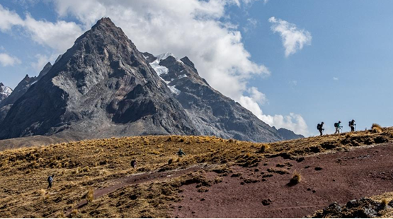
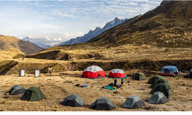
6:30 AM Early breakfast and departure This morning, we start at 7:00 am driving up and out of town to the Northwest, 1 hour and 20 minutes later we get to Killarumiyoq archeological site, a place that will trip you through the history of the incas. We continue via vehicle to the bustling town of Limatambo, the last little town, after it we leave the paved way to start a new road that will take us to the Choquetera Valley, We arrive at the trailhead for a delicious lunch that our crew got for us, all of this before beginning our trek up the valley, following a road initially and then branching off onto a small footpath after crossing a river. With picturesque views of 17,000 ft Jatunsaya mountain, our path today is a small local one, used only by the families of this area. Rated moderate to challenging, we have our work cut out for us as we ascend quit a lot in a small amount of mileage. We start off strong with this initial ascent into the mighty Andes with a steady steep incline, leveling out in our final approach to camp. You will sleep well tonight Our campsite is right at the end of a new road. 13,800 ft 6:30 pm Dinner and group briefing
➢ Ascent: 1994 ft
➢ Descent: 98 ft
➢ Distance hike: 3 miles
➢ Difficulty: Moderate Challenging
-
Meals Today: B, L, D
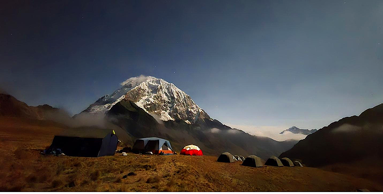
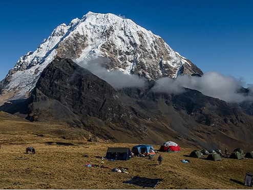
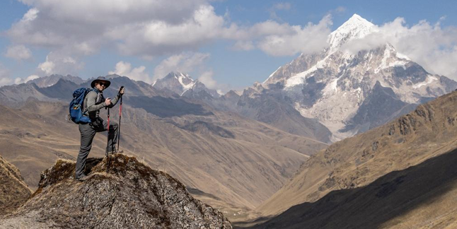
6:00 AM Wake-up call 7:00- 8:00 AM Breakfast and departure We are up and at it early this morning, as today we have three passes to cross. Diverging from the trail we used yesterday; we hike steadily upward until we come to two vibrant mountain moraines. If we're quiet in the morning hours, this trail is so remote we have a good chance of seeing some wildlife. Deer, foxes and the famous condor often frequent this area. After to enjoy the Qoyllor lake we come to our first pass of the day; which, at 14,760ft, is our first massive achievement of the trek. This is where we start to glimpse the western slopes of jagged Humantay mountain. We continue our descent down, then up again and here is where the mighty Salkantay mountain is revealed to us. Not far beyond is our second pass- Japanese Camp Pass. We cross this pass at approximately 14,860ft and from here we can see our lunch spot at Japanese camp. Here we can explore two beautiful moraine lakes beneath Salkantay mountain at 14,500ft. After lunch we pick our way up a set of rocky switchbacks to ascend our final pass- Inka Chiriaska (the Frozen Inka) at 15,334ft. Descending sharply we are overwhelmed by the sound of a long winding waterfall cascading from the glacier, flowing around the base of Salkantay mountain. Working our way around the south side of the mountain, we hug the hillsides encountering a well marked, genuine ancient Incan trail. Finally, returning to 14,650 ft we find our Toqto campsite, perched at the base with astounding views of Salkantay.
➢ Distance: 8 miles
➢ Elevation gain: 2600 ft
➢ Elevation loss:1730 ft
➢ Difficulty: Moderate Challenging
-
Meals Today: B, L, D 6:20 AM Wake-up call 7:00- 8:00 AM Breakfast and departure The adventures continue, we will hit three more high passes today, though today is decidedly more mellow than the previous two days with more total descent than ascent. We begin the day with a gradual ascent up to our 1st pass of the day- Tocto pass. At 14,783ft it boasts the most picturesque view of Salkantay Mountain of the whole trip- so drink it in as it's our last view until camp tonight. While our ascent was gradual- the descent off this pass is somewhat steep until it levels off, hugging a valley wall at about 14,000ft. Then, it's up again to our 2nd pass of the day at 14,356 ft and down again to 14,500ft. We continue skirting the head of a valley with some more ups and downs, following the folds of the mountain. Our 3rd and final pass of the day is another 2 miles away and has us back at 14,337ft. After this pass we descend down into a new valley where we once again glimpse massive Salkantay, this time having worked our way around to her eastern flanks, and a whole new view. Tonight, we camp in a vast meadow at 13,618ft.
➢ Distance: 5.5 miles
➢ Elevation gain: 1060 ft
➢ Elevation loss:2086 ft
➢ Difficulty: Moderate
-
Meals Today: B, L, D 6:20 AM Wake-up call 7:00- 8:00 AM Breakfast and departure Today is considered as one of the biggest and also most challenging days. Ascending out of our camp, we make our way steadily up a rocky incline rising a little under 700ft total to our first pass at 14,337ft, from here we’ll get the last glimpse of the Apu Salkantay, then we continue getting down to the Yawar Maki Valley where we stop to recover ourselves, then hike up to our second pass at 13,530 ft. an amazing view of the valleys around. From our pass and subsequent descent, a whole new mountain range - the Quelhuacocha valley is revealed to us. It's black and red jagged peaks hover above us as we continue our descent, here a little break before to restart with an aggressive pass ascent as we climb more than 2,000ft in less than 2 miles. Is in the way up that our crew fixed a beautiful lunch spot 13,487ft. Energy recovered to finish the final ascent to the last pass of the day, Accocasa Pass 14,688ft. From here we have a steady descent down to our camp site Inkaracay 13,854ft, veering off to the valley at the right; enjoying inescapable views of the massive black jagged peaks of Nevado Huayanay range that dominate at almost 18,000ft.
➢ Distance: 8,6 miles
➢ Elevation gain: 3,152 ft
➢ Elevation loss: 2,896 ft
➢ Difficulty: Moderate challenging
-
Meals Today: B, L, D 6:00 AM Wake-up call 6:00- 7:00 AM Breakfast and departure Today we have one of the reasons why we consider this a unique and very original trek, the newest rainbow mountain only for the ones that got the hoghs passes of Salkantay, we start after our delicious breakfast, an uphill surrounded of beautiful mountains, specially the Apu Huayanay, after an hour we get to the base of the rainbow mountain, colorfull natural mountain, perfect place for pictures right before to star the final little up to the last pass of the trip 15,082 ft, as soon we get over, the view of a different valley comes out new views, getting into the Urubamba mountain range We celebrate having hit our 9th (and final) pass before descending to the sweet shores of gorgeous Ancascocha- Blue Lake. Aptly named, you'll revel in the bright blue waters fed by a remarkable waterfall- the perfect setting to celebrate the rigorous day's accomplishments.
➢ Distance: 7.7 miles
➢ Elevation gain: 1,614 ft
➢ Elevation loss: 2,995 ft
➢ Difficulty: Moderate
-
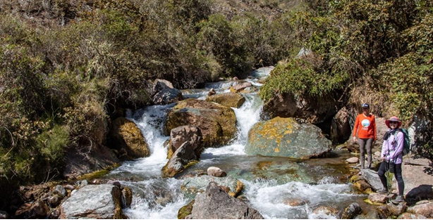
Meals Today: B, L, D 6:00 AM Wake-up call 6:00- 7:00 AM Breakfast and departure Today we have a long but steady descent out of the valley. Eventually our path takes us riverside and we find ourselves crisscrossing the river over a series of rudimentary wooden bridges. Making our way down and out of this beautiful valley; we notice as Eucalyptus trees start to pepper the landscape and the flora become lusher and more verdant. Our constant guide as we continue our descent is the prominent Mt. Veronica- looming almost 20,000ft above the Urubamba valley; and a most dominant portion of the horizon in these parts. Resurfacing back into civilization; eventually we meet up with a gravel road and follow it to the remote community of Chillca. Here is where our private transport awaits us to deliver us to Cusco.
➢ Distance: 6.46 miles
➢ Elevation gain: 393 ft
➢ Elevation loss: 3,536 ft
➢ Difficulty: Easy Moderate
-
Transportation
• Private mountain guide (Assistance guide after 8 people groups)
• Entrance tickets to Inca Trail
• All the meals during the Trek • Cheffs and Staff during the trek
• Medical kit and Oxygen
• Camping gear (Sleeping bags, tents, dining tents, toilet tent, shower tent)
• Dinner in Ollantaytambo
-
Doesn’t included the MachuPicchu Citadel visit.
Any activity not mentioned in the program
Extra Expenses
Gratuities to the staff
Travel Insurance
-
50% at the time of reservation
50% 30 days before departure.